


Cannero Riviera - Monte Morissolo

cron
User
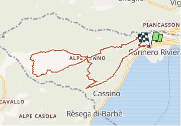

Length
10.7 km

Max alt
1290 m

Uphill gradient
1106 m
Km-Effort
25 km

Min alt
231 m

Downhill gradient
1107 m
Boucle
Yes
Creation date :
2020-02-17 16:38:54.441
Updated on :
2020-02-17 16:41:40.186
5h50
Difficulty : Difficult

FREE GPS app for hiking
 SityTrail
IGN / Geographical institutes
SityTrail Plus
The world is yours!
About
Trail On foot of 10.7 km to be discovered at Piemont, Verbano-Cusio-Ossola, Cannero Riviera. This trail is proposed by cron.
Positioning
Country:
Italy
Region :
Piemont
Department/Province :
Verbano-Cusio-Ossola
Municipality :
Cannero Riviera
Location:
Unknown
Start:(Dec)
Start:(UTM)
475179 ; 5096541 (32T) N.
Comments